
In the wake of a natural disaster, communities are in shock, having endured unimaginable trauma. Time becomes an invaluable resource as people scramble to pick up the pieces. The urgency to deploy services to affected individuals is paramount. Simultaneously, businesses seeking to support these communities face a daunting task – site selection in a time-sensitive and highly dynamic environment. Companies must find the people needing their services quickly, to provide time-sensitive services.
The process of identifying people impacted by a natural disaster who are candidates for your services doesn’t need to be an unbearable challenge. This is where GIS Site Selection Tools and agile decision-making come into play, catalyzing the ability to respond effectively and compassionately. At Flourish & Thrive Labs, our geospatial expertise was instrumental in empowering an organization to swiftly step into action by providing them with a ranked list of candidates to conduct outreach to.
Table of Contents
Setting the Scenario: Addressing the Urgency of Post-Disaster Services
Flourish & Thrive Labs was contracted by an organization specializing in providing services in the aftermath of natural disasters. The time-sensitive nature of these services meant that speed and efficiency in identifying potential customers were critical. However, the organization faced a formidable challenge. With a complex business model and operating at a large scale, sifting through potential leads was becoming exceedingly time-consuming and inefficient.
Recognizing the urgency and complexity of this situation, Flourish & Thrive Labs embarked on a long-term engagement with the organization. We became an integral part of their geospatial team, immersing ourselves in their processes and workflows.
A significant component of our engagement was to revamp the site identification process and develop a GIS Site Selection tool. This revamp was about creating efficient tools and gaining a deep understanding of the organization’s requirements so that the tool could become part of their workflow and DNA.
We engaged in thorough analysis and utilized GIS technologies to streamline the site identification process, ensuring that the organization could rapidly and effectively pinpoint those in need of their services after a natural disaster. By developing these tools and refining the organization’s needs, we played a crucial role in transforming how they operated in these pressing circumstances. Through our collaboration, the organization became better equipped to serve communities efficiently when they needed it the most.
The Importance of Site Identification
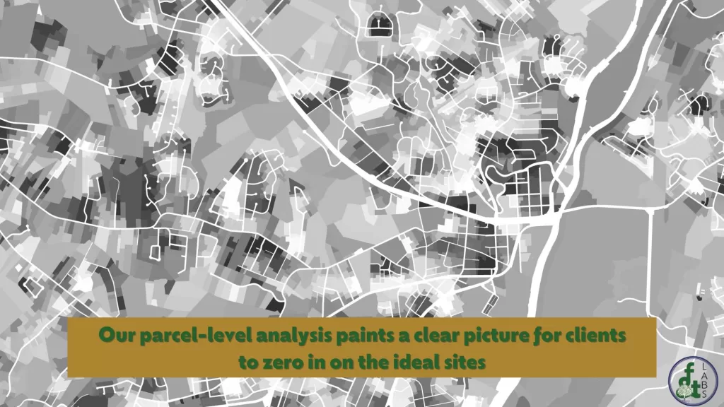
While often referred to as site selection, the process is truly about site identification. In the aftermath of a natural disaster, it’s essential to pinpoint who has been impacted and who among them qualifies for the specific services that an organization or business can provide.
This process demands sifting through a plethora of information. Understanding the disaster’s path, the characteristics of affected sites, and specifics about the communities involved is paramount. Site identification is not just about selecting locations; it’s about recognizing the people who inhabit these areas and their needs.
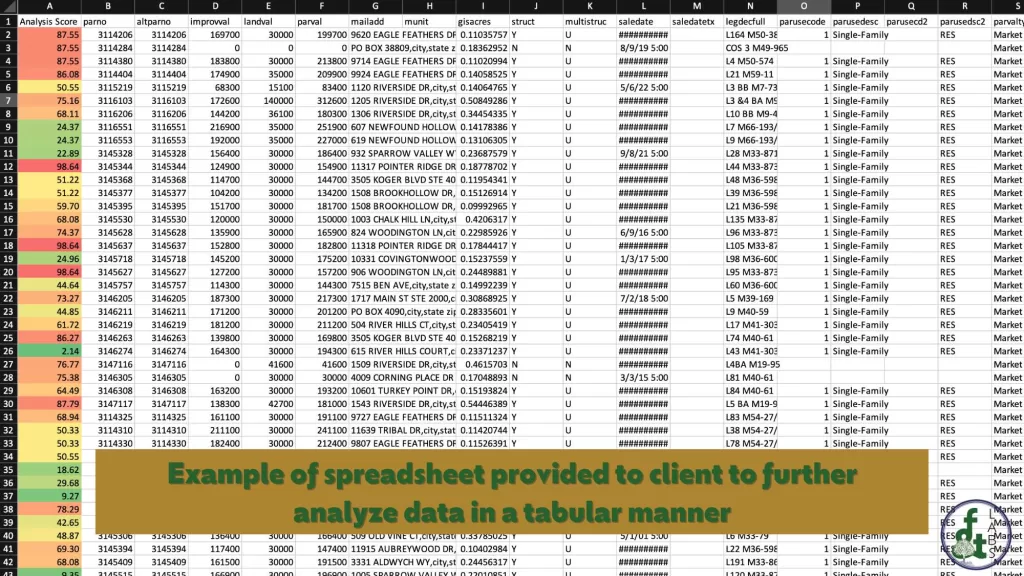
In disaster scenarios, approaching this analytically from remote settings is invaluable. This minimizes the risks associated with immediate physical engagement in affected areas and expedites the identification process. By using GIS tools, organizations can distill essential data to identify suitable sites and potential beneficiaries rapidly. Once a list of potential sites are identified that meet specific qualifications, such as being in a disaster zone, having land characteristics, and land-ownership details a team can more effectively conduct outreach. This efficiency aids in formulating effective strategies for resource deployment.
Hence, site identification and GIS site selection is the linchpin that determines how quickly and effectively support reaches the people impacted by natural disasters. Through precise identification, resources can be allocated more thoughtfully, ensuring aid arrives where it’s most needed.
Harnessing GIS for Precision and Speed
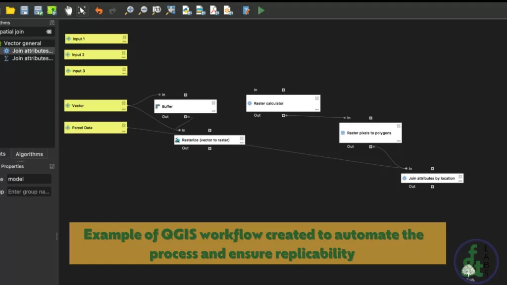
Geospatial Information Systems (GIS) allow for analyzing spatial data and relationships on the earth’s surface. For this project, Flourish & Thrive Labs leveraged cutting-edge geospatial technology including QGIS and Carto, to assist an organization in making informed, rapid decisions in site selection following natural disasters. Through these tools, we analyze diverse spatial data such as land slope, current land use, and proximity to accessibility points, allowing businesses to efficiently and effectively identify potential sites to deploy their services.
Automation for Transformation
Automation plays a critical role in transforming site selection processes. We empowered our client with a repeatable and efficient process by developing a tool that automates the site selection process. We utilized the QGIS graphical modeler to create a tool that not only streamlined the site selection process but was also user-friendly. This was essential as it enabled less technical GIS analysts to understand and modify the tool to meet evolving needs. This kind of adaptability is crucial in disaster response, where conditions change rapidly.
THRIVE Consulting Methodology in Action
Our THRIVE process was critical to the success of this project. Starting with ‘Take Note’, we developed an initial approach based on the organization’s goals. In the ‘Huddle’ stage, we worked closely with the client to refine and prioritize these goals, ensuring that we were in sync with their time constraints and budget. We also communicated consistently about our findings and what goals were feasible.
During ‘Implementation’, we sat shoulder-to-shoulder with the client’s team for six months, integrating ourselves into their processes, understanding their challenges, and fostering a transformation in their lead generation system. This collaborative approach not only expedited the site selection process but also enabled them to serve affected communities more efficiently.
Finally, the ‘Exit’ stage focused on documentation and knowledge transfer. We ensured that the client had thorough documentation of the decisions made regarding datasets and the analysis tool, enabling them to use the tools in future endeavors independently. At Flourish and Thrive Labs, we have the goal to “Be the consultants clients are glad to have had, but never need again.” This project demonstrated that capability through a smooth handoff of our tools and knowledge.
Wrapping Up
When disaster strikes, the need for fast, informed, and empathetic action is paramount. Through geospatial analysis, automation, agile consulting, and empowering culture, Flourish & Thrive Labs enables organizations to swiftly and effectively identify sites for service deployment in post-disaster scenarios. We are proud to contribute to the rebuilding and healing of communities in need. If you are interested in learning more about the services that we offer, please take a moment to shoot us a note. We would love to find a time to chat with you about how our services can aid your work!
Demonstration Graphics to Illustrate Our Work
Please note that the images included in this blog post are demonstration graphics, created for illustrative purposes to provide insight into our work. To protect our clients and our intellectual property these images are not the actual client deliverables and are illustrative of the work that we do.